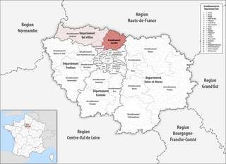
arrondissement of Saint-Denis, Seine-Saint-Denis (arrondissement de Saint-Denis)

- arrondissement of France in Île-de-France
- Country:

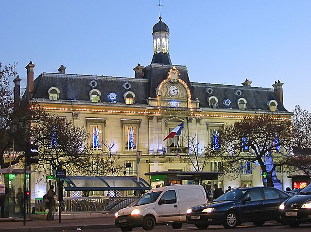
- Capital: Saint-Denis
- Coordinates: 48° 56' 1" N, 2° 21' 23" E


- GPS tracks (wikiloc): [Link]
- Area: 47 sq km
- Population: 429266
- Wikipedia en: wiki(en)
- Wikipedia: wiki(fr)
- Wikidata storage: Wikidata: Q517570
- Freebase ID: [/m/09s8gb]
- GeoNames ID: Alt: [2980915]
- BnF ID: [107598343]
- VIAF ID: Alt: [306352698]
- INSEE arrondissement code: [933]
Includes regions:

canton of Saint-Denis-Sud
- canton of France (until March 2015)
- Country:
- Capital: Saint-Denis
- Coordinates: 48° 55' 0" N, 2° 21' 0" E
- GPS tracks (wikiloc): [Link]

canton of Aubervilliers-Est
- canton of France (until March 2015)
- Country:
- Capital: Aubervilliers
- Coordinates: 48° 54' 48" N, 2° 23' 41" E
- GPS tracks (wikiloc): [Link]

canton of Saint-Ouen
- canton of France
- Country:
- Capital: Saint-Ouen
- Coordinates: 48° 54' 30" N, 2° 20' 0" E
- GPS tracks (wikiloc): [Link]
- Population: 87947
canton of Saint-Denis-Nord-Ouest
- canton of France (until March 2015)
- Country:
- Capital: Saint-Denis
- Coordinates: 48° 57' 0" N, 2° 21' 0" E
- GPS tracks (wikiloc): [Link]
canton of Pierrefitte-sur-Seine
- canton of France (until March 2015)
- Country:
- Capital: Pierrefitte-sur-Seine
- Coordinates: 48° 58' 0" N, 2° 22' 0" E
- GPS tracks (wikiloc): [Link]

canton of Aubervilliers-Ouest
- canton of France (until March 2015)
- Country:
- Capital: Aubervilliers
- Coordinates: 48° 55' 0" N, 2° 23' 0" E
- GPS tracks (wikiloc): [Link]
canton of Saint-Denis-Nord-Est
- canton of France (until March 2015)
- Country:
- Capital: Saint-Denis
- Coordinates: 48° 56' 14" N, 2° 22' 19" E
- GPS tracks (wikiloc): [Link]

canton of Épinay-sur-Seine
- canton of France
- Country:
- Capital: Épinay-sur-Seine
- Coordinates: 48° 57' 0" N, 2° 18' 0" E
- GPS tracks (wikiloc): [Link]
- Population: 65150

Saint-Denis
- commune in Seine-Saint-Denis, Paris agglomeration, France
- Country:
- Postal Code: 93210; 93200
- Coordinates: 48° 56' 8" N, 2° 21' 14" E
- GPS tracks (wikiloc): [Link]
- Area: 12.36 sq km
- Population: 111103
- Web site: [Link]

canton of La Courneuve
- canton of France
- Country:
- Capital: La Courneuve
- Coordinates: 48° 55' 56" N, 2° 23' 48" E
- GPS tracks (wikiloc): [Link]
- Population: 68477
Shares border with regions:


arrondissement of Nanterre
- arrondissement of France
- Country:
- Capital: Nanterre
- Coordinates: 48° 53' 40" N, 2° 12' 12" E
- GPS tracks (wikiloc): [Link]
- Population: 889155


arrondissement of Argenteuil
- arrondissement of France
- Country:
- Capital: Argenteuil
- Coordinates: 48° 56' 51" N, 2° 14' 56" E
- GPS tracks (wikiloc): [Link]
- Area: 108.62 sq km
- Population: 408510


arrondissement of Le Raincy
- arrondissement of France
- Country:
- Capital: Le Raincy
- Coordinates: 48° 53' 52" N, 2° 31' 11" E
- GPS tracks (wikiloc): [Link]
- Area: 123 sq km
- Population: 750425


arrondissement of Bobigny
- arrondissement of France
- Country:
- Capital: Bobigny
- Coordinates: 48° 54' 25" N, 2° 26' 22" E
- GPS tracks (wikiloc): [Link]
- Population: 412972

arrondissement of Sarcelles
- French arrondissement in Val-d'Oise
- Country:
- Capital: Sarcelles
- Coordinates: 48° 59' 50" N, 2° 22' 43" E
- GPS tracks (wikiloc): [Link]
- Area: 364 sq km
- Population: 469702