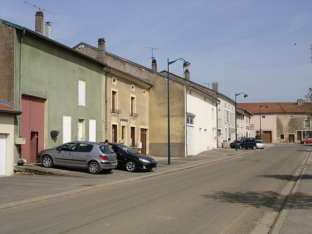
Liverdun (Liverdun)

- commune in Meurthe-et-Moselle, France
- Country:

- Postal Code: 54460
- Coordinates: 48° 45' 1" N, 6° 3' 43" E


- GPS tracks (wikiloc): [Link]
- Area: 25.23 sq km
- Population: 6033
- Web site: http://www.liverdun.com
- Wikipedia en: wiki(en)
- Wikipedia: wiki(fr)
- Wikidata storage: Wikidata: Q903665
- Wikipedia Commons Category: [Link]
- Freebase ID: [/m/0gb3dg]
- Freebase ID: [/m/0gb3dg]
- GeoNames ID: Alt: [2998078]
- GeoNames ID: Alt: [2998078]
- SIREN number: [215403189]
- SIREN number: [215403189]
- BnF ID: [152643874]
- BnF ID: [152643874]
- VIAF ID: Alt: [168307283]
- VIAF ID: Alt: [168307283]
- Library of Congress authority ID: Alt: [n91066406]
- Library of Congress authority ID: Alt: [n91066406]
- WOEID: [608278]
- WOEID: [608278]
- EMLO location ID: [9927647f-a2b7-4665-a778-b8d4648ec573]
- EMLO location ID: [9927647f-a2b7-4665-a778-b8d4648ec573]
- Digital Atlas of the Roman Empire ID: [20120]
- Digital Atlas of the Roman Empire ID: [20120]
- INSEE municipality code: 54318
- INSEE municipality code: 54318
Shares border with regions:
Aingeray
- commune in Meurthe-et-Moselle, France
- Country:
- Postal Code: 54460
- Coordinates: 48° 44' 20" N, 6° 0' 6" E
- GPS tracks (wikiloc): [Link]
- Area: 12.79 sq km
- Population: 558
Sexey-les-Bois
- commune in Meurthe-et-Moselle, France
- Country:
- Postal Code: 54840
- Coordinates: 48° 42' 56" N, 6° 1' 10" E
- GPS tracks (wikiloc): [Link]
- Area: 6.81 sq km
- Population: 362
Velaine-en-Haye
- commune in Meurthe-et-Moselle, France
- Country:
- Postal Code: 54840
- Coordinates: 48° 42' 10" N, 6° 1' 16" E
- GPS tracks (wikiloc): [Link]
- Area: 17.87 sq km
- Population: 1821


Villey-Saint-Étienne
- commune in Meurthe-et-Moselle, France
- Country:
- Postal Code: 54200
- Coordinates: 48° 43' 51" N, 5° 58' 40" E
- GPS tracks (wikiloc): [Link]
- Area: 17.29 sq km
- Population: 1104

Rosières-en-Haye
- commune in Meurthe-et-Moselle, France
- Country:
- Postal Code: 54385
- Coordinates: 48° 47' 34" N, 6° 0' 3" E
- GPS tracks (wikiloc): [Link]
- Area: 10.74 sq km
- Population: 242
- Web site: [Link]


Jaillon
- commune in Meurthe-et-Moselle, France
- Country:
- Postal Code: 54200
- Coordinates: 48° 45' 24" N, 5° 58' 5" E
- GPS tracks (wikiloc): [Link]
- Area: 7.47 sq km
- Population: 469


Frouard
- commune in Meurthe-et-Moselle, France
- Country:
- Postal Code: 54390
- Coordinates: 48° 45' 38" N, 6° 7' 44" E
- GPS tracks (wikiloc): [Link]
- Area: 12.96 sq km
- Population: 6638
- Web site: [Link]


Marbache
- commune in Meurthe-et-Moselle, France
- Country:
- Postal Code: 54820
- Coordinates: 48° 47' 50" N, 6° 6' 8" E
- GPS tracks (wikiloc): [Link]
- Area: 10.63 sq km
- Population: 1724
- Web site: [Link]

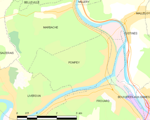
Pompey
- commune in Meurthe-et-Moselle, France
- Country:
- Postal Code: 54340
- Coordinates: 48° 46' 5" N, 6° 7' 39" E
- GPS tracks (wikiloc): [Link]
- Area: 8.13 sq km
- Population: 4878


Champigneulles
- commune in Meurthe-et-Moselle, France
- Country:
- Postal Code: 54250
- Coordinates: 48° 44' 1" N, 6° 9' 52" E
- GPS tracks (wikiloc): [Link]
- Area: 23.99 sq km
- Population: 6808
- Web site: [Link]

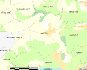
Saizerais
- commune in Meurthe-et-Moselle, France
- Country:
- Postal Code: 54380
- Coordinates: 48° 47' 25" N, 6° 2' 39" E
- GPS tracks (wikiloc): [Link]
- Area: 14.44 sq km
- Population: 1548