
Thuringia (Thüringen)


- state of Germany
 Hiking in Thuringia
Thuringia, located in central Germany, is an excellent destination for hiking enthusiasts. Known for its diverse landscapes, lush forests, historical sites, and picturesque villages, Thuringia offers numerous trails that cater to different skill levels and interests. Here are some highlights and tips for hiking in the region:
Key Hiking Areas
-
Thuringian Forest (Thüringer Wald):
- This is one of the most famous hiking regions in Thuringia. The area is characterized by dense forests, mountains, and stunning viewpoints. The Rennsteig trail, a long-distance hiking path, runs 168 kilometers along the crest of the Thuringian Forest, providing panoramic vistas and a chance to explore the area's natural beauty.
-
National Park Hainich:
- A UNESCO World Heritage Site, Hainich is known for its beech forests and rich biodiversity. There are well-marked trails that take you through the park, including options for shorter walks and longer hikes. The park also features the exciting Baumwipfelpfad (Canopy Walkway), which offers a unique perspective of the treetops.
-
Vesser Valley and the "Himmelsleiter" (Sky Ladder):
- This scenic area is great for hiking, with trails that lead you through striking landscapes, waterfalls, and clear rivers. "Himmelsleiter" is a challenging ascent that provides rewarding views.
-
Saale Valley:
- The Saale River offers beautiful river valley hiking, with gentle paths and more challenging elevations nearby. This region is also rich in cultural history and historic towns.
Recommendations for Hikers
-
Trail Marking: Trails in Thuringia are generally well-marked with signs and symbols. Familiarize yourself with the trail markers and maps, available at visitor centers and online.
-
Seasonal Considerations: While hiking is possible year-round, spring and autumn offer particularly pleasant weather and stunning foliage. Summer can be warm, while winter hiking can be enjoyable with appropriate gear.
-
Equipment: Always wear sturdy hiking boots and carry sufficient water, snacks, a map or GPS device, and weather-relevant clothing. In the forested areas, a good set of trekking poles can be helpful.
-
Nature and Wildlife: Keep an eye out for local wildlife, including deer and a variety of bird species. Respect the environment by staying on marked paths and following Leave No Trace principles.
-
Cultural Sites: Don’t miss the chance to explore historic towns like Weimar, Jena, and Erfurt, which are rich in culture and history. Many hiking trails also lead to castles and other cultural landmarks.
-
Guided Tours: For those unfamiliar with the area or looking for a more informative experience, consider joining a guided hike. Local guides often provide insights into the natural and cultural history of the region.
Thuringia is a beautiful place to explore on foot, and it promises a mix of natural beauty and cultural experiences that make for unforgettable hiking adventures!
- Country:

- Capital: Erfurt
- Coordinates: 50° 51' 40" N, 11° 3' 7" E


- GPS tracks (wikiloc): [Link]
- AboveSeaLevel: 266 м m
- Area: 16171.0 sq km
- Population: 2161000
- Web site: http://www.thueringen.de/
- Wikipedia en: wiki(en)
- Wikipedia: wiki(de)
- Wikidata storage: Wikidata: Q1205
- Wikipedia Commons Gallery: [Link]
- Wikipedia Commons Category: [Link]
- Wikipedia Commons Maps Category: [Link]
- Freebase ID: [/m/07nf6]
- GeoNames ID: Alt: [2822542]
- BnF ID: [11933497h]
- VIAF ID: Alt: [138407449]
- OSM relation ID: [62366]
- GND ID: Alt: [4059979-6]
- archINFORM location ID: [2930]
- Library of Congress authority ID: Alt: [n82255658]
- PACTOLS thesaurus ID: [pcrtSjse6h5A6k]
- MusicBrainz area ID: [ff2ee1ad-febe-4b48-8999-e77870b62744]
- Quora topic ID: [Thuringia]
- TGN ID: [7003689]
- Encyclopædia Britannica Online ID: [place/Thuringia]
- Encyclopædia Universalis ID: [thuringe]
- ISNI: Alt: [0000 0004 0629 4046]
- NKCR AUT ID: [ge128467]
- DMOZ ID: Alt: [Regional/Europe/Germany/States/Thuringia/]
- National Library of Israel ID: [000997608]
- NUTS code: [DEG0]
- YSO ID: [138239]
- Klexikon article ID: [Thüringen]
- BabelNet ID: [00077133n]
- STW Thesaurus for Economics ID: [18136-6]
- ISO 3166-2 code: DE-TH
- German regional key: 16
- FIPS 10-4 (countries and regions): GM15
- GACS ID: 19015
Includes regions:

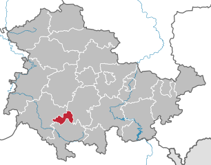
Suhl
- town in Thuringia, Germany
Hiking in Suhl
Suhl, located in the Thuringia region of Germany, is surrounded by stunning natural landscapes, making it a wonderful destination for hiking enthusiasts. The area is characterized by diverse terrains, including forests, hills, and picturesque valleys, offering a range of trails suitable for all skill levels....
- Country:
- Postal Code: 98711; 98530; 98529; 98527
- Local Dialing Code: 036782; 036846; 03681
- Licence Plate Code: SHL
- Coordinates: 50° 36' 38" N, 10° 41' 35" E
- GPS tracks (wikiloc): [Link]
- AboveSeaLevel: 422 м m
- Area: 103.02 sq km
- Population: 36208
- Web site: [Link]


Erfurt
- capital city of German federated state of Thuringia
Hiking in Erfurt
Hiking around Erfurt, the capital of Thuringia in central Germany, offers a unique blend of natural beauty and cultural experiences. The region is characterized by picturesque landscapes, rolling hills, and charming villages, as well as numerous trails suitable for all hiking levels. Here are some highlights to consider:...
- Country:
- Postal Code: 99099; 99098; 99097; 99096; 99095; 99094; 99092; 99091; 99090; 99089; 99087; 99086; 99085; 99084
- Local Dialing Code: 36204; 36203; 36202; 36208; 361
- Licence Plate Code: EF; LF; L
- Coordinates: 50° 58' 41" N, 11° 1' 45" E
- GPS tracks (wikiloc): [Link]
- AboveSeaLevel: 194 м m
- Area: 269.91 sq km
- Population: 211113
- Web site: [Link]


Jena
- city in Thuringia, Germany
Hiking in Jena
Jena, located in the Thuringia region of Germany, offers a variety of hiking opportunities surrounded by beautiful landscapes, historic sites, and diverse ecosystems. Here are some key points to consider when hiking in and around Jena:...
- Country:
- Postal Code: 07749; 07747; 07745; 07743; 07751
- Local Dialing Code: 036425; 03641
- Licence Plate Code: J
- Coordinates: 50° 55' 38" N, 11° 35' 11" E
- GPS tracks (wikiloc): [Link]
- AboveSeaLevel: 158 м m
- Area: 114.76 sq km
- Population: 108207
- Web site: [Link]


Gera
- town in Thuringia, Germany
Hiking in Gera
Gera, located in the heart of Thuringia, Germany, offers a unique blend of hiking opportunities that cater to various skill levels. The surrounding region features beautiful landscapes, rich history, and diverse flora and fauna, making it an attractive destination for outdoor enthusiasts....
- Country:
- Postal Code: 07557; 07545
- Local Dialing Code: 0365
- Licence Plate Code: G
- Coordinates: 50° 52' 41" N, 12° 4' 57" E
- GPS tracks (wikiloc): [Link]
- AboveSeaLevel: 205 м m
- Area: 152.19 sq km
- Population: 96011
- Web site: [Link]


Weimar
- city in Thuringia, Germany
Hiking in Weimar
Weimar, located in the heart of Germany, is not only famous for its rich cultural history but also offers some beautiful walking and hiking opportunities. Here are some highlights and suggestions for hiking in and around Weimar:...
- Country:
- Postal Code: 99427; 99425; 99423
- Local Dialing Code: 036453; 03643
- Licence Plate Code: WE
- Coordinates: 50° 59' 0" N, 11° 19' 0" E
- GPS tracks (wikiloc): [Link]
- AboveSeaLevel: 208 м m
- Area: 84.48 sq km
- Population: 64131
- Web site: [Link]


Eisenach
- municipality in Thuringia, Germany
Hiking in Eisenach
Eisenach, located in central Germany, is surrounded by stunning landscapes and rich history, making it an excellent destination for hiking enthusiasts. Here’s what you need to know about hiking in and around Eisenach:...
- Country:
- Postal Code: 99817
- Local Dialing Code: 036928; 036920; 03691
- Licence Plate Code: EA
- Coordinates: 50° 58' 29" N, 10° 19' 28" E
- GPS tracks (wikiloc): [Link]
- AboveSeaLevel: 215 м m
- Area: 104.17 sq km
- Population: 42417
- Web site: [Link]
Nordhausen
- district in Thuringia, Germany
Hiking in Nordhausen
Nordhausen district, located in the state of Thuringia, Germany, offers a variety of hiking opportunities that appeal to both casual walkers and experienced hikers. The region is characterized by its beautiful landscapes, historical sites, and diverse ecosystems, making it a great destination for outdoor enthusiasts....
- Country:
- Licence Plate Code: NDH
- Coordinates: 51° 30' 0" N, 10° 43' 48" E
- GPS tracks (wikiloc): [Link]
- AboveSeaLevel: 232 м m
- Area: 713.91 sq km
- Population: 85355
- Web site: [Link]

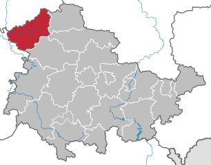
Eichsfeld
- district in Thuringia, Germany
Hiking in Eichsfeld
Eichsfeld is a picturesque district located in the central part of Germany, primarily in the state of Thuringia, with some areas extending into Lower Saxony. This region is characterized by rolling hills, dense forests, and beautiful landscapes, making it an excellent destination for hiking enthusiasts....
- Country:
- Licence Plate Code: WBS; HIG; EIC
- Coordinates: 51° 19' 48" N, 10° 15' 0" E
- GPS tracks (wikiloc): [Link]
- AboveSeaLevel: 438 м m
- Area: 943.07 sq km
- Population: 101325
- Web site: [Link]
Kyffhäuserkreis
- district in Thuringia, Germany
Hiking in Kyffhäuserkreis
Kyffhäuserkreis, located in the central part of Germany in the state of Thuringia, is known for its picturesque landscapes, historic sites, and diverse hiking opportunities. Here are some key highlights about hiking in this region:...
- Country:
- Licence Plate Code: SDH; ART; KYF
- Coordinates: 51° 19' 48" N, 10° 55' 12" E
- GPS tracks (wikiloc): [Link]
- AboveSeaLevel: 288 м m
- Area: 1037.89 sq km
- Population: 77110
- Web site: [Link]
Unstrut-Hainich-Kreis
- district in Thuringia, Germany
Hiking in Unstrut-Hainich-Kreis
Unstrut-Hainich-Kreis is a beautiful district located in Thuringia, Germany, known for its scenic landscapes, rich history, and diverse hiking opportunities. The region is home to the Unstrut River and part of the Hainich National Park, which is recognized for its ancient beech forests and biodiversity....
- Country:
- Licence Plate Code: UH
- Coordinates: 51° 10' 12" N, 10° 30' 0" E
- GPS tracks (wikiloc): [Link]
- AboveSeaLevel: 196 м m
- Area: 979.69 sq km
- Population: 105273
- Web site: [Link]
Sömmerda
- district in Thuringia, Germany
Hiking in Sömmerda
Sömmerda is a district located in the state of Thuringia, Germany. It offers a variety of hiking opportunities, with landscapes that include rural countryside, forests, and quaint villages. Here are some aspects to consider when planning a hiking trip in Sömmerda:...
- Country:
- Licence Plate Code: SÖM
- Coordinates: 51° 9' 36" N, 11° 9' 36" E
- GPS tracks (wikiloc): [Link]
- AboveSeaLevel: 138 м m
- Area: 806.84 sq km
- Population: 70600
- Web site: [Link]
Wartburgkreis
- district in Thuringia, Germany
Hiking in Wartburgkreis
Wartburgkreis, located in Thuringia, Germany, offers a variety of hiking opportunities amidst stunning natural landscapes, historical sites, and diverse ecosystems. The region is known for its scenic beauty, characterized by rolling hills, dense forests, and beautiful valleys....
- Country:
- Coordinates: 50° 55' 12" N, 10° 15' 0" E
- GPS tracks (wikiloc): [Link]
- AboveSeaLevel: 344 м m
- Area: 1307.43 sq km
- Population: 125655
- Web site: [Link]
Gotha
- district in Thuringia, Germany
Hiking in Gotha
Gotha district, located in the state of Thuringia in central Germany, offers a variety of hiking opportunities for nature enthusiasts and outdoor adventurers. The region is characterized by its picturesque landscapes, historical sites, and diverse ecosystems, making it a great destination for hiking....
- Country:
- Licence Plate Code: GTH
- Coordinates: 50° 55' 12" N, 10° 45' 0" E
- GPS tracks (wikiloc): [Link]
- AboveSeaLevel: 338 м m
- Area: 936.08 sq km
- Population: 136831
- Web site: [Link]
Schmalkalden-Meiningen
- district in Thuringia, Germany
Hiking in Schmalkalden-Meiningen
Schmalkalden-Meiningen, located in the state of Thuringia, Germany, offers a variety of hiking opportunities that cater to both casual walkers and experienced hikers. The region is characterized by its picturesque landscapes, including forests, hills, and historical towns, making it an attractive destination for outdoor enthusiasts. Here are some key highlights:...
- Country:
- Licence Plate Code: SM
- Coordinates: 50° 40' 12" N, 10° 25' 12" E
- GPS tracks (wikiloc): [Link]
- AboveSeaLevel: 478 м m
- Area: 1210.73 sq km
- Population: 124623
- Web site: [Link]
Hildburghausen
- district of Thuringia, Germany
Hiking in Hildburghausen
Hildburghausen is a picturesque district located in the state of Thuringia, Germany, known for its diverse landscapes, history, and plenty of outdoor activities, including hiking. Here are some highlights for hiking in the Hildburghausen district:...
- Country:
- Licence Plate Code: HBN
- Coordinates: 50° 25' 12" N, 10° 45' 0" E
- GPS tracks (wikiloc): [Link]
- AboveSeaLevel: 482 м m
- Area: 938.42 sq km
- Population: 64524
- Web site: [Link]
Sonneberg
- district of Thuringia, Germany
Hiking in Sonneberg
Sonneberg, located in the southern part of Germany, in the state of Thuringia, offers a variety of hiking opportunities that cater to different skill levels and preferences. The district is characterized by its beautiful landscapes, including rolling hills, dense forests, and picturesque valleys....
- Country:
- Licence Plate Code: SON; NH
- Coordinates: 50° 24' 36" N, 11° 7' 48" E
- GPS tracks (wikiloc): [Link]
- AboveSeaLevel: 594 м m
- Area: 433.61 sq km
- Population: 56818
- Web site: [Link]
Ilm-Kreis
- district in Thuringia, Germany
Hiking in Ilm-Kreis
Ilm-Kreis, located in the state of Thuringia, Germany, offers a diverse range of hiking opportunities with beautiful landscapes, rich history, and charming villages. Here are some highlights of hiking in this area:...
- Country:
- Coordinates: 50° 45' 0" N, 11° 0' 0" E
- GPS tracks (wikiloc): [Link]
- AboveSeaLevel: 416 м m
- Area: 843.71 sq km
- Population: 109620
- Web site: [Link]
Weimarer Land
- district in Thuringia, Germany
Hiking in Weimarer Land
Weimarer Land, located in the state of Thuringia, Germany, is a picturesque region that offers a diverse range of hiking opportunities. The area is steeped in history and culture, with connections to famous figures like Goethe and Schiller who spent significant time in nearby Weimar. Here’s what you can expect when hiking in Weimarer Land:...
- Country:
- Licence Plate Code: APD; AP
- Coordinates: 51° 0' 0" N, 11° 25' 12" E
- GPS tracks (wikiloc): [Link]
- AboveSeaLevel: 263 м m
- Area: 804.48 sq km
- Population: 82127
- Web site: [Link]
Saalfeld-Rudolstadt
- district in Thuringia, Germany
Hiking in Saalfeld-Rudolstadt
Saalfeld-Rudolstadt, located in Thuringia, Germany, is known for its diverse and picturesque landscapes, making it an excellent destination for hiking enthusiasts. The region features a mix of forests, hills, and rivers, providing a variety of trails suitable for all skill levels....
- Country:
- Licence Plate Code: SLF; RU
- Coordinates: 50° 40' 12" N, 11° 19' 48" E
- GPS tracks (wikiloc): [Link]
- AboveSeaLevel: 668 м m
- Area: 1036.03 sq km
- Population: 109278
- Web site: [Link]


Saale-Orla-Kreis
- district in Thuringia, Germany
Hiking in Saale-Orla-Kreis
Hiking in Saale-Orla-Kreis, located in the Free State of Thuringia, Germany, offers a wonderful experience for outdoor enthusiasts. The region is characterized by its diverse landscapes, which include rolling hills, dense forests, vibrant meadows, and charming villages. Here’s a brief overview of what hikers can expect in this area:...
- Country:
- Capital: Schleiz
- Licence Plate Code: SOK
- Coordinates: 50° 34' 48" N, 11° 45' 0" E
- GPS tracks (wikiloc): [Link]
- AboveSeaLevel: 472 м m
- Area: 1151.3 sq km
- Population: 82951
- Web site: [Link]
Saale-Holzland-Kreis
- district in Thuringia, Germany
Hiking in Saale-Holzland-Kreis
Saale-Holzland-Kreis, located in the state of Thuringia, Germany, is a picturesque area known for its beautiful landscapes, dense forests, and charming villages. Here’s a guide to hiking in this region:...
- Country:
- Licence Plate Code: SHK
- Coordinates: 50° 55' 12" N, 11° 45' 0" E
- GPS tracks (wikiloc): [Link]
- AboveSeaLevel: 306 м m
- Area: 815.25 sq km
- Population: 86184
- Web site: [Link]
Greiz
- district in Thuringia, Germany
Hiking in Greiz
Greiz, located in the state of Thuringia, Germany, offers a variety of hiking opportunities that showcase the stunning landscapes and rich history of the region. Here are some key points to consider about hiking in Greiz:...
- Country:
- Licence Plate Code: ZR; GRZ
- Coordinates: 50° 45' 0" N, 12° 4' 48" E
- GPS tracks (wikiloc): [Link]
- AboveSeaLevel: 366 м m
- Area: 845.98 sq km
- Population: 101114
- Web site: [Link]
Altenburger Land
- district in Thuringia, Germany
Hiking in Altenburger Land
Altenburger Land, located in Thuringia, Germany, offers a variety of hiking opportunities that showcase its beautiful landscapes, rich history, and unique cultural heritage. Here are some key aspects of hiking in this region:...
- Country:
- Licence Plate Code: SLN; ABG
- Coordinates: 51° 0' 0" N, 12° 25' 0" E
- GPS tracks (wikiloc): [Link]
- AboveSeaLevel: 236 м m
- Area: 569.41 sq km
- Population: 91607
- Web site: [Link]
Shares border with regions:


Lower Franconia
- administrative region of Franconia in Bavaria, Germany
Hiking in Lower Franconia
Lower Franconia, located in the northern part of Bavaria, Germany, is a great destination for hiking enthusiasts. This region is known for its diverse landscapes that range from rolling hills to picturesque vineyards and nature reserves, offering a variety of trails suitable for different skill levels....
- Country:
- Capital: Würzburg
- Coordinates: 50° 1' 28" N, 9° 55' 55" E
- GPS tracks (wikiloc): [Link]
- AboveSeaLevel: 289 м m
- Area: 8530.99 sq km
- Population: 1298849
- Web site: [Link]


Lower Saxony
- state of Germany
Hiking in Lower Saxony
Lower Saxony, located in northwestern Germany, offers a diverse range of hiking opportunities appealing to both novice and experienced hikers. Here are some of the highlights of hiking in Lower Saxony:...
- Country:
- Capital: Hanover
- Coordinates: 52° 45' 22" N, 9° 23' 35" E
- GPS tracks (wikiloc): [Link]
- AboveSeaLevel: 13 м m
- Area: 47614.07 sq km
- Population: 7945685
- Web site: [Link]


Hesse
- state in Germany
Hiking in Hesse
Hesse, located in central Germany, offers a diverse range of hiking opportunities, thanks to its varied landscapes that include forests, hills, and charming villages. Here are some highlights of hiking in the region:...
- Country:
- Capital: Wiesbaden
- Coordinates: 50° 39' 58" N, 8° 35' 28" E
- GPS tracks (wikiloc): [Link]
- AboveSeaLevel: 264 м m
- Area: 21100.0 sq km
- Population: 6045425
- Web site: [Link]


Saxony
- state in Germany
Hiking in Saxony
Saxony, located in the eastern part of Germany, is a fantastic destination for hiking enthusiasts due to its diverse landscapes, rich natural beauty, and well-maintained trails. Here are some highlights and tips for hiking in Saxony:...
- Country:
- Capital: Dresden
- Coordinates: 51° 1' 37" N, 13° 21' 32" E
- GPS tracks (wikiloc): [Link]
- AboveSeaLevel: 342 м m
- Area: 18415.66 sq km
- Population: 4055274
- Web site: [Link]


Saxony-Anhalt
- state of Germany
Hiking in Saxony-Anhalt
Saxony-Anhalt, located in central Germany, offers a diverse range of hiking trails and natural landscapes that cater to outdoor enthusiasts. Here are some key highlights for hiking in this region:...
- Country:
- Capital: Magdeburg
- Coordinates: 51° 58' 16" N, 11° 28' 12" E
- GPS tracks (wikiloc): [Link]
- AboveSeaLevel: 51 м m
- Area: 20451.58 sq km
- Population: 2245470
- Web site: [Link]


Bavaria
- state in Germany
Hiking in Bavaria
Hiking in Bavaria is a fantastic experience, offering a diverse range of landscapes, stunning views, and well-marked trails. Here are some key highlights and tips for hiking in Bavaria:...
- Country:
- Capital: Munich
- Coordinates: 48° 46' 39" N, 11° 25' 52" E
- GPS tracks (wikiloc): [Link]
- AboveSeaLevel: 503 м m
- Area: 70551 sq km
- Population: 12930751
- Web site: [Link]