
Vorarlberg (Vorarlberg)


- federal state of Austria
 Hiking in Vorarlberg
Vorarlberg, the westernmost province of Austria, is a fantastic destination for hiking enthusiasts. Nestled between the Alps and the Rhine River, it offers a diverse landscape with breathtaking views, lush valleys, and well-marked trails catering to various skill levels.
Key Features of Hiking in Vorarlberg:
-
Diverse Terrain: From gentle hills to challenging mountain paths, Vorarlberg has something for everyone. Popular areas include the Bregenz Forest, the Rätikon mountain range, and the Silvretta Alps.
-
Well-Marked Trails: The region boasts an extensive network of hiking trails. Many routes are clearly signposted, making it easy for hikers to navigate. Trail difficulty ranges from easy family-friendly walks to more demanding alpine hikes.
-
Stunning Scenery: Hikers can enjoy spectacular views of the mountains, valleys, and lakes. The Bodensee (Lake Constance) offers a beautiful backdrop, especially on trails near the lake's shoreline.
-
Flora and Fauna: Vorarlberg is rich in biodiversity. Hikers can encounter a variety of wildlife and plant species along the trails, especially in nature reserves and protected areas.
-
Charming Villages: Many hiking routes pass through traditional Austrian villages, where you can experience local culture, cuisine, and hospitality. These villages often feature rustic accommodations, making them great places to stay overnight during multi-day hikes.
-
Seasonal Hiking: While summer is the most popular time for hiking, the region also offers opportunities for winter hiking and snowshoeing, particularly in higher altitudes.
-
Guided Tours: For those who prefer a more structured experience, guided hiking tours are available. Local guides can provide insights into the area’s flora, fauna, and history.
Popular Hiking Areas:
- Bregenz Forest: Known for its lush landscapes and picturesque trails, it's ideal for families and nature lovers.
- Räithong Ridge: Offers stunning panoramic views and a range of hiking options from easy to challenging.
- Silvretta Region: Known for its high alpine trails, this area is perfect for experienced hikers wanting to explore rugged terrain.
Tips for Hiking in Vorarlberg:
- Check Weather Conditions: The weather in the mountains can change rapidly. Always check forecasts before heading out.
- Proper Gear: Wear appropriate hiking boots and clothing suited for mountains. Bring essentials like water, snacks, and a first-aid kit.
- Trail Maps: While many trails are well-marked, it’s a good idea to carry a map or GPS device, especially for remote areas.
- Respect Nature: Follow Leave No Trace principles to help preserve the stunning landscapes.
Whether you're looking for a peaceful walk alongside a lake or a challenging hike in the Alps, Vorarlberg has plenty to offer to satisfy your hiking cravings. Happy trails!
- Country:

- Capital: Bregenz
- Coordinates: 47° 14' 37" N, 9° 53' 38" E


- GPS tracks (wikiloc): [Link]
- AboveSeaLevel: 1063 м m
- Area: 2601.48 sq km
- Population: 388711
- Web site: http://www.vorarlberg.at/
- Wikipedia en: wiki(en)
- Wikipedia: wiki(de)
- Wikidata storage: Wikidata: Q38981
- Wikipedia Commons Gallery: [Link]
- Wikipedia Commons Category: [Link]
- Wikipedia Commons Maps Category: [Link]
- Freebase ID: [/m/015g43]
- GeoNames ID: Alt: [2762300]
- BnF ID: [12178506f]
- VIAF ID: Alt: [124343663]
- GND ID: Alt: [4063944-7]
- archINFORM location ID: [2948]
- Library of Congress authority ID: Alt: [n81054176]
- PACTOLS thesaurus ID: [pcrts05IRIh88I]
- MusicBrainz area ID: [eacec681-6fb0-4e14-96a1-e181320c5c07]
- Quora topic ID: [Vorarlberg]
- TGN ID: [7018001]
- SUDOC authorities ID: [030352177]
- Encyclopædia Britannica Online ID: [place/Vorarlberg]
- Encyclopædia Universalis ID: [vorarlberg]
- ISNI: Alt: [0000 0001 0657 0969]
- NKCR AUT ID: [ge137282]
- DMOZ ID: Alt: [Regional/Europe/Austria/Provinces/Vorarlberg/]
- NUTS code: [AT34]
- Klexikon article ID: [Vorarlberg]
- Ringgold ID: [60167]
- Global Anabaptist Mennonite Encyclopedia Online ID: [Vorarlberg (Austria)]
- STW Thesaurus for Economics ID: [16954-3]
- ISO 3166-2 code: AT-8
- FIPS 10-4 (countries and regions): AU08
Includes regions:

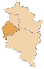
Feldkirch District
- district of Austria
Hiking in Feldkirch District
Feldkirch District, located in the western part of Austria, is known for its stunning landscapes, rich history, and diverse hiking trails. Nestled at the foot of the Alps and bordered by Switzerland and Liechtenstein, this area offers a wide range of hiking opportunities suitable for different skill levels....
- Country:
- Capital: Feldkirch
- Licence Plate Code: FK
- Coordinates: 47° 16' 44" N, 9° 39' 50" E
- GPS tracks (wikiloc): [Link]
- AboveSeaLevel: 450 м m
- Area: 278.26 sq km
- Population: 104048
- Web site: [Link]

Dornbirn District
- district of Austria
Hiking in Dornbirn District
Dornbirn District, located in the western part of Austria, is a beautiful region known for its stunning landscapes, diverse hiking trails, and outdoor activities. Situated at the northern edge of the Alps, it offers a mix of mountainous terrain, lush valleys, and scenic views of the Rhine Valley and Lake Constance....
- Country:
- Capital: Dornbirn
- Licence Plate Code: DO
- Coordinates: 47° 25' 0" N, 9° 45' 0" E
- GPS tracks (wikiloc): [Link]
- AboveSeaLevel: 956 м m
- Area: 172.37 sq km
- Population: 86272
- Web site: [Link]
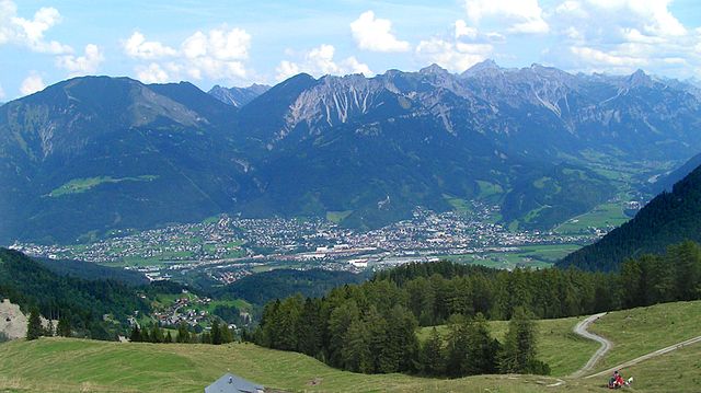
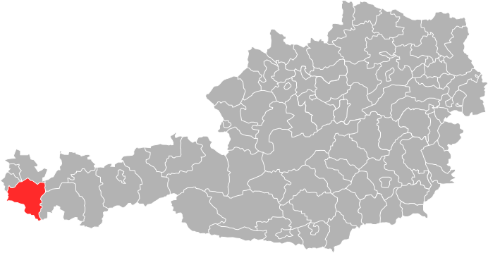
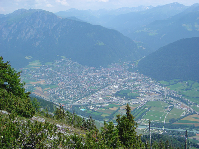
Bludenz District
- district (Bezirk) Bludenz, Vorarlberg, Austria
Hiking in Bludenz District
Bludenz District, located in the western part of Austria, is a fantastic destination for hiking enthusiasts. Nestled in the scenic Vorarlberg region, it offers a diverse landscape that includes lush valleys, towering mountains, and picturesque villages. Here are some highlights and recommendations for hiking in this area:...
- Country:
- Capital: Bludenz
- Licence Plate Code: BZ
- Coordinates: 47° 6' 0" N, 9° 54' 0" E
- GPS tracks (wikiloc): [Link]
- AboveSeaLevel: 566 м m
- Area: 1287.52 sq km
- Web site: [Link]

Bregenz District
- district in Austria
Hiking in Bregenz District
Bregenz District, located in the western part of Austria in the state of Vorarlberg, offers a variety of stunning hiking opportunities, thanks to its diverse landscapes that include lakes, mountains, and picturesque villages. Here are some highlights and tips for hiking in this beautiful region:...
- Country:
- Capital: Bregenz
- Licence Plate Code: B
- Coordinates: 47° 24' 0" N, 10° 0' 0" E
- GPS tracks (wikiloc): [Link]
- AboveSeaLevel: 771 м m
- Area: 863.34 sq km
- Population: 131350
- Web site: [Link]
Shares border with regions:
Graubünden
- canton of Switzerland
Hiking in Graubünden
The Canton of Grisons, or Graubünden, is a breathtaking region in Switzerland known for its stunning landscapes, diverse hiking trails, and rich cultural heritage. Here are some highlights of hiking in this beautiful area:...
- Country:

- Capital: Chur
- Licence Plate Code: GR
- Coordinates: 46° 45' 0" N, 9° 30' 0" E
- GPS tracks (wikiloc): [Link]
- AboveSeaLevel: 585 м m
- Area: 7105.39 sq km
- Web site: [Link]


Canton of St. Gallen
- canton of Switzerland
Hiking in Canton of St. Gallen
The Canton of St. Gallen, located in eastern Switzerland, is a fantastic destination for hiking enthusiasts, boasting a diverse range of trails that cater to various skill levels and interests. Here's an overview of what you can expect:...
- Country:
- Capital: St. Gallen
- Licence Plate Code: SG
- Coordinates: 47° 20' 0" N, 9° 10' 0" E
- GPS tracks (wikiloc): [Link]
- AboveSeaLevel: 668 м m
- Area: 2030.75 sq km
- Population: 75538
- Web site: [Link]


Tyrol
- federal state in western Austria
Hiking in Tyrol
Tyrol, located in the Austrian Alps, is a paradise for hiking enthusiasts, offering a diverse array of trails that cater to all skill levels. The landscape is characterized by stunning mountain vistas, lush valleys, sparkling lakes, and charming alpine villages, making it a perfect setting for outdoor activities....
- Country:
- Capital: Innsbruck
- Coordinates: 47° 16' 0" N, 11° 24' 0" E
- GPS tracks (wikiloc): [Link]
- AboveSeaLevel: 605 м m
- Area: 12647.71 sq km
- Population: 739002
- Web site: [Link]


Bavaria
- state in Germany
Hiking in Bavaria
Hiking in Bavaria is a fantastic experience, offering a diverse range of landscapes, stunning views, and well-marked trails. Here are some key highlights and tips for hiking in Bavaria:...
- Country:

- Capital: Munich
- Coordinates: 48° 46' 39" N, 11° 25' 52" E
- GPS tracks (wikiloc): [Link]
- AboveSeaLevel: 503 м m
- Area: 70551 sq km
- Population: 12930751
- Web site: [Link]


Baden-Württemberg
- federal state in the South-West of Germany
Hiking in Baden-Württemberg
Baden-Württemberg, located in southwestern Germany, is a fantastic region for hiking enthusiasts. With its diverse landscapes, from the Black Forest to the Swabian Jura and picturesque vineyards along the Rhine River, the area offers a variety of trails suitable for all skill levels. Here are some highlights:...
- Country:
- Capital: Stuttgart
- Coordinates: 48° 32' 16" N, 9° 2' 28" E
- GPS tracks (wikiloc): [Link]
- AboveSeaLevel: 327 м m
- Area: 35751.65 sq km
- Population: 10703000
- Web site: [Link]